


Mapping Medellín's hillsides: how communities are putting themselves on the map to manage disaster risk
Posted by Mar Marín Villagrana • Oct. 21, 2026
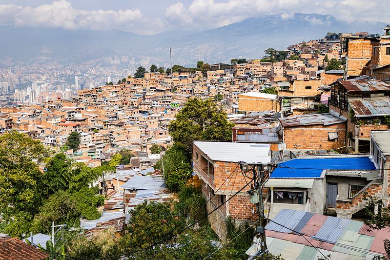
In April 2026, a fire swept through Carpinelo, in Medellín's Comuna 3. When the Colombian Red Cross and Medellín's Administrative Department for Disaster Risk Management (DAGRD) arrived, they did not start from scratch. The homes, paths, and facilities of Carpinelo and neighboring Carambolas were already in OpenStreetMap, published by the Hillsides Mapping School. With that data, responders could find their way through steep streets and self-built paths and reach affected families faster.
That data was produced by residents themselves, phone in hand, walking their own neighborhoods. So when the emergency came, the neighborhood already knew itself.
“I think it's very important for people to truly take ownership of these tools, which are open access and community-based, and to begin empowering themselves over their own territory, getting to know it.” Angie Vanesa Caro, participant in the Carpinelo community.
Living on the hillsides, missing from the map
Many of Medellín's hillside neighborhoods are self-built, raised by their residents' own hands, often families displaced by the armed conflict. The eastern hillside alone is home to around 452,000 people, almost 85% of them in the lowest socioeconomic strata. Many of these neighborhoods do not appear in the city's Land Use Plan (POT), which limits their access to basic services and makes them hard to plan for or reach when landslides, floods, or fires strike.
Led by the Center for Studies on Populations, Mobilizations and Territories (POMOTE) at the Universidad Autónoma Latinoamericana (UNAULA), with the support of Psicólogas sin Fronteras, and in partnership with HOT's Latin America and the Caribbean Open Mapping Hub, the Hillside Mapping School aim is a collaborative ecosystem between community, academia, and public institutions, where open data shapes the decisions that affect life on the hillsides.
“Organizations usually know a great deal about the needs and the potential of their territories, but they rarely have the tools to hold very direct conversations with institutions.” Leonardo Jiménez García, director of POMOTE.
Between December 2025 and June 2026, leaders from the eastern and western hillsides and the rural districts of Santa Elena, San Cristóbal, and San Sebastián de Palmitas trained in OpenStreetMap, Tasking Manager, uMap, Mapillary, StreetComplete, and ChatMap, grounded in popular education and community-based risk management. The deepest learning happened on five field walks, from La Divisa in Comuna 13 to El Picacho in Comuna 6, where participants captured street-level imagery and learned to plan drone flights.
“Much of what we mapped today isn't on well-known platforms like Google, because of the kind of routes we walked: stairways, alleys, connections to main roads.” Deisy López, El Picacho, Comuna 6.

A participant of the Hillside Mapping School traces rooftops over aerial imagery in HOT's Tasking Manager as part of a risk mapping project for Vereda Mazo, in the Santa Elena district of Medellín.
“Sometimes people want to map their daily lives, their neighborhood relationships, and that doesn't appear on a city hall map. But if the people themselves can do it, I think that's the power of these tools.” Itzamar Cuervo, La Divisa, Comuna 13
On June 19, 2026, 20 leaders were certified after 96 hours of training. Psicólogas sin Fronteras and Ciudad en Movimiento supported the sessions and map validation, the audiovisual collective Desenfoque documented the process, and three open mapathons brought in 55 more people.
ChatMap: early warnings from the neighborhood WhatsApp group

Community members take part in a hillside mapping activity in Medellín. WhatsApp is already part of daily life in many neighborhoods, and ChatMap turns the photos, videos, and locations residents share there into a map, supporting community-led risk monitoring without learning a new tool.
Everyone on the hillsides already uses WhatsApp. Building on that, the School trained 40 leaders from community risk management committees in Comunas 3, 8, and 9 in the ChatMap protocol: photograph a critical point, share its location in the group, and turn the chat into a map. The workshops identified 87 risk conditions and created six WhatsApp groups for monitoring and early warning, including one for volunteers who watch over the Santa Elena stream.
“It's a new technology, a faster way to log the chaotic points, the risk points in our community, both here and in other parts of Medellín.” Berna Gómez, participant in the first ChatMap workshop with public officials and social organizations.
When the map becomes a tool
In its first semester, the School produced 20 Tasking Manager projects that added more than 33,000 buildings and 158 km of roads to OpenStreetMap, 10 interactive maps in uMap, more than 6,000 street-level images, and 12 high-resolution drone mapping products. What matters most is what communities are doing with them:
- A neighborhood census. In La Divisa, Comuna 13, the Community Action Board used the map as the basis for its first community census.
- Petitions backed by data. Women leaders of the Comuna 9 risk management committee have filed formal petitions (derechos de petición) with the Environment Secretariat and the DAGRD, maps attached, to push for mitigation works along the Santa Elena stream.
- A place in the Land Use Plan. Maps of neighborhoods absent from the POT, such as Villatina La Torre, Carambolas, and Nueva Jerusalén, will inform the Plan's update, seeking official recognition and better social services. In Carambolas, the map will also support a food sovereignty report on its community gardens.
- Evidence in court. Data mapped in an earlier cycle of the School is now evidence in a class action brought by the Universidad de Antioquia Legal Clinic for victims of a hailstorm in Granizal. The map identifies 125 of the 160 water tanks serving an area where 55,000 people live.
The School's OpenStreetMap data is now a layer in Medellín's official Geoportal, making previously invisible homes, roads, and facilities visible to public officials and residents. The School was also selected as a pilot for the district roundtable on open geographic data, and UNAULA and District Planning are advancing a cooperation agreement to integrate community data on an ongoing basis. At the university, a Mapping MediaLab is opening for community use, and a Master's in Critical Geography and Open Data is planned for 2027.
The path has not been simple. Steep terrain and airspace restrictions complicate drone flights, connectivity is limited in remote areas, and the intensity of the work stretched the teaching team. That is why the next cycle will focus on training more community trainers.
Still, the lesson is clear: open data becomes advocacy when there is an ecosystem that uses it. On Medellín's hillsides, that ecosystem is already in motion, woven together by organized communities, a committed university, institutions willing to listen, and an open mapping network. Neighborhoods long absent from official maps now have something no one can take away: the capacity to map themselves.
“It's about standing by one another: knowing what's happening with our neighbors, who lives farther away, who is facing what, and how we can contribute so that together we grow as communities.” Angie Vanesa Caro, participant.
Learn more about the School, its maps, and its open data on the Hillside Mapping School microsite.
Share